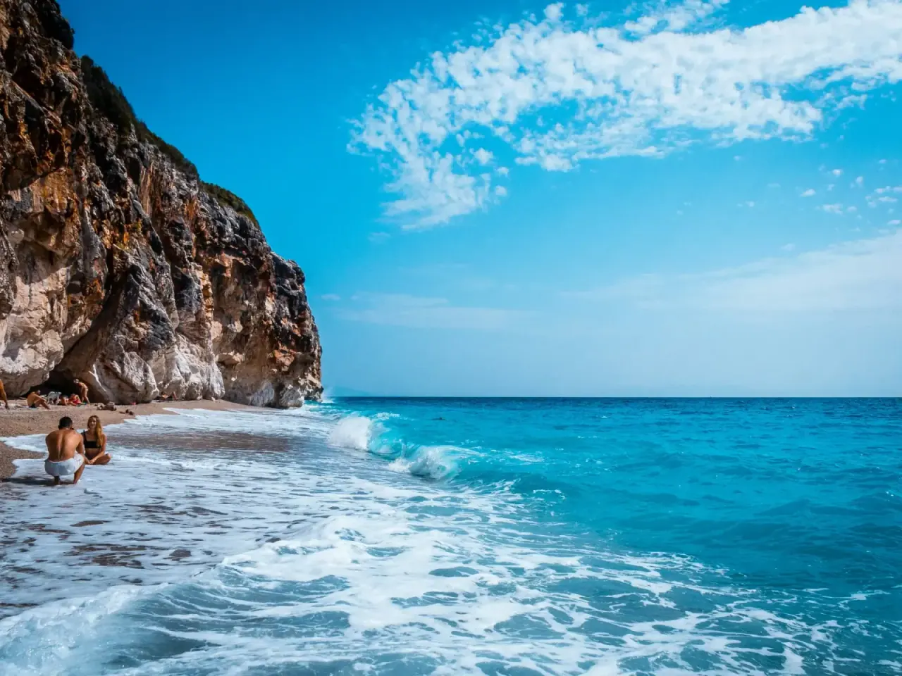
Llogara Pass is the gateway to the Albanian Riviera. At 1,027 meters above sea level, the road climbs through the Ceraunian Mountains in a series of hairpin turns, cuts through dense pine forest, and then opens up to one of the most jaw-dropping panoramas in the Mediterranean: the entire Ionian coastline laid out below, turquoise water stretching to the horizon, and on clear days, the island of Corfu floating in the distance. It's the single most dramatic road in Albania, and driving it is a highlight of any Riviera trip.
The pass sits on SH8, the main coastal highway connecting Vlore in the north to Himara, Saranda, and the rest of the Riviera in the south. Every traveler heading to the coast by road will cross it. Some rush through in a bus with the curtains drawn. That's a mistake. Llogara Pass deserves at least a couple of hours — ideally half a day — to stop at the viewpoints, walk into the national park, eat lamb at a mountain restaurant, and take in the view that Julius Caesar himself reportedly saw over two thousand years ago.
Compare hotels, apartments, and Vrbo rentals on the map. Powered by Stay22.
Book tours & activities: Compare guided day trips, boat tours, and excursions on GetYourGuide.
Quick Overview
| Detail | |
|---|---|
| Elevation | 1,027 m |
| Road | SH8, paved, narrow with hairpin turns |
| From Vlore | ~40 min to the pass summit |
| From Himara | ~25 min to the pass summit |
| Vlore to Himara (full crossing) | ~1.5 hours |
| Highlights | Panoramic viewpoints, Llogara National Park, flag pines, Caesar's Pass, paragliding |
| Best time to drive | Clear mornings, May–October |
| Fuel | No stations between Vlore and Himara — fill up before |
The Drive: What to Expect
Coming from Vlore (North Side)
Most travelers approach from the north, either driving from Tirana via Vlore or starting a Riviera road trip. From Vlore's southern outskirts, the SH8 begins climbing almost immediately. The road is paved the entire way but narrow — mostly two lanes with no divider, tight bends, and occasional construction zones.
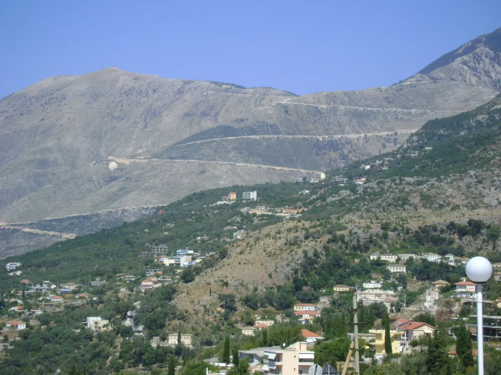
The first 15 minutes are through lower hills with olive groves and scrubland. Then the forest thickens. Black pine and fir trees close in on both sides. The road steepens. Hairpin turns start stacking up — you'll count a dozen or more before the summit. Each switchback climbs higher, and gaps in the tree canopy start revealing slices of the coast you just left behind.
Near the top, the forest opens and you hit the viewpoints. This is where you pull over. The panorama from 1,000+ meters is the Albanian Riviera in its entirety: Dhermi directly below, the beaches of Drymades and Gjipe curving south, Himara in the distance, and the deep blue Ionian stretching west toward Corfu and Italy. On a clear morning, the visibility is extraordinary.
Coming from Himara (South Side)
From Himara, the climb is shorter but steeper. The road winds up through terraced hillsides above the coast, offering constantly shifting angles on the beaches below. You'll pass through the village of Palase — one of the oldest settlements on the coast — before the switchbacks begin in earnest. Allow 25 minutes to reach the summit from Himara's center.
The south side has some of the best individual viewpoints because you're looking back down at the coast you just drove along. Several informal pull-offs exist with enough room for 2-3 cars. Stop at any of them.
Road Conditions
The road is fully paved but not a highway. Expect:
- Narrow lanes with no center divider on most sections
- Tight hairpin turns where buses and trucks swing wide — hug your side
- Occasional construction (Albania is constantly improving its roads, but closures and one-lane sections happen without warning)
- Gravel shoulders where the pavement meets the mountain — be careful pulling over
- Livestock — goats, sheep, and occasionally wild horses cross the road without notice
- Tour buses taking the turns slowly — be patient, passing opportunities are limited
Drive defensively. Albanian driving culture is assertive. Locals will overtake on blind curves. Keep your speed moderate, headlights on, and horn ready for blind bends. Check current road conditions for Albania before driving, especially in winter or wet weather.
Key Stops Along the Route
Here's a suggested stop plan driving north to south (Vlore to Himara). All distances and times are from Vlore.
| Stop | Distance from Vlore | Drive Time | What You'll See |
|---|---|---|---|
| Forest zone begins | ~15 km | 20 min | Pine forest canopy closes over the road |
| First viewpoint | ~22 km | 30 min | First Riviera panorama through the trees |
| Llogara Pass summit | ~27 km | 40 min | Main viewpoint, restaurants, national park entrance |
| Flag pines | ~28 km | 42 min | Wind-sculpted pines bent horizontal by mountain gusts |
| Caesar's Pass marker | ~29 km | 44 min | Historical marker where Caesar reportedly crossed |
| Paragliding launch | ~28 km | 42 min | Tandem flights launch from near the summit |
| South-side viewpoints | ~32 km | 50 min | Downhill views toward Palase and Dhermi beaches |
| Arrive Himara | ~52 km | 1 hr 25 min | End of the pass, coast level |
You don't need to stop at every point. At minimum, stop at the summit viewpoint and the flag pines. If you have time, the national park trails and a restaurant lunch are worth building into the day.
Llogara National Park
The pass sits within Llogara National Park, a 1,010-hectare protected area of dense pine and fir forest covering the Ceraunian mountain slopes. The park is free to enter and open year-round, though trails are best from May to October.
Hiking Trails
Several marked trails begin near the summit parking areas and restaurants. They range from easy 30-minute walks to full-day mountain ascents.
Short walks (30 min – 1 hour):
- Viewpoint loop trail — Flat, easy path through pine forest to a cleared overlook facing south. Good for anyone, including families with children. Starts behind the main restaurant cluster at the summit.
- Flag pines trail — Short walk from the road to the grove of wind-sculpted pines (more on these below). Flat terrain, 15-20 minutes round trip.
Medium hikes (2–4 hours):
- Caesar's Trail — Follows the ridge south from the pass summit with continuous coastal views. Moderate difficulty, some rocky sections. About 3 hours round trip.
- Forest loop — Deeper into the park's interior. Thick canopy, quieter, chance of seeing wildlife. About 2 hours.
Full-day hike:
- Mount Cika summit — The highest peak in the Ceraunian range at 2,044 meters. A serious hike requiring 6-8 hours round trip, proper gear, and water. The trail is not always well-marked above the treeline. Start early and check conditions locally. The summit views are extraordinary — you can see from Vlore to Saranda and across to Corfu — but this is a real mountain hike, not a stroll.
No entrance fee. No ticket booth. You just walk in. Trails are signed at the start but can become faint higher up. Download offline maps before you go. Cell service is unreliable at the pass.
Caesar's Pass
The pass takes part of its historical significance from Julius Caesar, who reportedly crossed the Ceraunian Mountains here in 48 BC while pursuing his rival Pompey during the Roman Civil War. Caesar landed at Palase (the beach settlement on the south side of the pass) and marched his legions over the mountains to reach the plains of northern Greece.
A small historical marker near the summit commemorates the crossing. The history is partly documented, partly legend — Roman sources confirm Caesar's campaign route through this region, but the exact mountain crossing point is debated by historians. Either way, standing at the pass and looking down at the coast where Roman triremes once anchored gives the landscape an extra layer of weight.
The name "Llogara" itself may derive from an older term for the narrow mountain passage, though etymologies vary. What's certain is that this route has been a strategic corridor for millennia — Romans, Ottomans, and World War II partisans all used it.
The Flag Pines
One of Llogara's most photographed features is the grove of flag pines (Pinus heldreichii and Pinus nigra) near the summit. Constant mountain winds from the Ionian Sea have bent these trees dramatically — their trunks grow vertically for a few meters, then curve sharply horizontal, with all branches extending in one direction like flags blowing in the wind.
The effect is striking and slightly surreal. The trees have been shaped by decades of persistent wind, and each one is a natural sculpture. The grove is a short walk from the road, well-signposted, and free to visit. Photography works best in morning light when the sun backlights the branches against the blue sky.
Locals sometimes refer to specific trees by shapes they resemble — you'll hear about "the eagle tree" and similar nicknames. The flag pines are unique to this microclimate and elevation. You won't see anything like them elsewhere on the Riviera.
Paragliding from Llogara Pass
The pass is one of the best paragliding launch sites in the Balkans. Tandem flights launch from approximately 1,000 meters elevation near the summit and glide down to Palase Beach or Dhermi Beach at sea level. The flight takes 15-25 minutes and offers a perspective on the Riviera that no viewpoint can match — you're floating above the cliffs, looking down at turquoise coves and white beaches from the air.
Practical Details
| Season | July – October (weather dependent) |
| Cost | 99–145€ for tandem flights |
| Experience needed | None — tandem means you fly with an instructor |
| Duration | 15–25 min flight, plus briefing and transport |
| Launch site | Near Llogara summit, ~1,000 m elevation |
| Landing | Palase or Dhermi beach |
| Booking | Book 1-2 days in advance in peak season through local operators |
| Weight limit | Typically up to 100-110 kg |
Flights are weather-dependent. Wind conditions at the pass can change quickly, and operators will cancel or delay if conditions aren't safe. Morning flights tend to have calmer air; afternoon thermals can make the ride bumpier (some people prefer that). If paragliding is a priority for your trip, build in a backup day in case your slot gets weathered out.
Several operators run tandem flights from the pass. Prices are fairly standardized. Higher-end packages include GoPro video and photos. Book through your accommodation in Himara or directly with operators — you'll find them listed on activity pages around the Riviera. See our activities page for current operators and options.
Restaurants at the Top
A cluster of traditional Albanian mountain restaurants sits at and near the Llogara summit. These are not tourist traps — they're the real thing. Many have been run by the same families for decades, serving food that comes from the mountains around you.
What to Eat
The specialty is mountain meat. Lamb and goat roasted slowly over wood fire, served with fresh bread, yogurt, and mountain greens. This is highland Albanian cooking — hearty, simple, and very good. Common dishes include:
- Mish qengji (roast lamb) — The signature dish. Slow-roasted, sometimes on a spit, served with bread and raw onion. 800–1,500 lek (7€–13) per portion.
- Mish keci (roast goat) — Similar preparation to lamb, slightly gamier, very tender when done well.
- Tavë kosi — Lamb baked in a yogurt-and-egg custard. A national Albanian dish that's especially good in the mountains where the lamb is local.
- Grilled vegetables — Peppers, tomatoes, eggplant from local gardens.
- Mountain tea (çaj mali) — Wild-harvested from the surrounding slopes. Served hot or cold. Mild, slightly floral, caffeine-free.
- Raki — Homemade grape spirit. Strong. Usually offered as a welcome shot.
Expect to spend 1,500–3,000 lek (13€–26) per person for a full meal with drinks. Portions are generous. Service is unhurried — this isn't a quick stop. Budget 45 minutes to an hour.
Some restaurants have terraces with views down to the coast. Eating roast lamb while looking at the Ionian Sea from 1,000 meters is one of those Albanian experiences that stays with you.
Practical Tips
Fog
Fog at Llogara Pass is common and can be dangerous. It rolls in quickly, especially in the morning before 9 AM and in the late afternoon after 5 PM. When it hits, visibility can drop to 10-20 meters. You'll go from clear mountain views to driving blind in minutes.
What to do:
- If fog is thick, slow down significantly and use low beams (not high beams — they reflect off the fog)
- Pull over at a safe spot if visibility drops below 20 meters
- Don't try to push through dense fog on unfamiliar mountain hairpins — it's not worth the risk
- If you're planning for views and photos, aim for mid-morning (10 AM – 2 PM) when fog is least likely
- Check conditions locally before driving — your hotel in Vlore or Himara can usually tell you what the pass looks like
Fuel
There are no fuel stations between Vlore and Himara. This is roughly 50 km of mountain road. If you're driving a rental car, fill your tank in Vlore (coming from the north) or Himara (coming from the south) before starting the pass. Running out of fuel on a mountain hairpin with no cell service is a scenario you want to avoid.
When to Drive
- Best: Clear mornings between 9 AM and 1 PM. Fog has usually burned off, light is good for photos, and you can see the full panorama.
- Good: Late morning to early afternoon. Warmest at the summit (which still means cool compared to the coast — bring a light layer).
- Avoid: Late afternoon and evening when fog is most likely. Also avoid driving the pass after dark unless you're experienced with mountain roads — there are no streetlights, no reflectors on some curves, and occasional animals on the road.
What to Bring
- Light jacket or fleece — The summit is 10-15°C cooler than the coast. Even in August, you'll want a layer.
- Water and snacks — Available at summit restaurants, but good to have in the car.
- Hiking shoes — If you plan to walk any trails beyond the roadside viewpoints.
- Offline maps — Cell service is patchy to nonexistent at the pass. Download Google Maps or Maps.me offline data before you go.
- Camera — Obviously. The summit viewpoints are some of the most photographed spots in Albania for good reason.
- Full fuel tank — Mentioned above, but worth repeating.
Wild Horses
You may spot wild or semi-wild horses grazing near the pass, particularly in meadows just off the road near the summit. They're generally calm and keep their distance from cars, but don't approach them. They're also an unpredictable road hazard — drive carefully through open meadow sections, especially around dawn and dusk.
The Llogara Tunnel Alternative
Since 2024, a tunnel bypasses the pass entirely, connecting the Vlore side directly to the south coast. This is faster (saving about 25-30 minutes) and avoids the mountain road conditions. The toll is 250 ALL (approximately 2€.50) for passenger cars, expected to be implemented starting late 2025.
History of the Pass
Llogara Pass has been a strategic corridor for as long as people have traveled this coast. The Ceraunian Mountains form a natural barrier between the lowlands of Vlore and the Riviera coast, and the pass is the lowest practical crossing point.
Ancient period: Greek colonists settled the coast below (Himara's name may derive from the Greek Chimaera). The pass connected coastal settlements to inland trade routes.
Roman period (48 BC): Julius Caesar crossed the mountains here during the civil war against Pompey. His forces landed at Palase beach and marched over the pass to reach Epirus. This is the most famous historical event associated with Llogara.
Ottoman period (15th–20th century): The Ottomans controlled this region for nearly five centuries. The pass was a military chokepoint and trade route. Several stone bridges and road remnants from this era survive in the surrounding mountains.
World War II: Albanian and Greek partisans used the mountains around the pass for resistance operations against Italian and German occupiers. The dense forest provided cover for guerrilla movements.
Modern era: The SH8 highway was paved through the pass in the communist period under Enver Hoxha's regime, connecting the isolated southern coast to the rest of the country. The road has been upgraded several times since, most recently with EU-funded improvements. The 2024 tunnel represents the latest chapter — modern infrastructure slowly supplementing the old mountain crossing while the scenic route endures.
How to Include Llogara Pass in Your Trip
The pass isn't a detour — it's on the main road. But rather than just driving through, here are a few ways to make the most of it.
Quick stop (1 hour): Pull over at the summit viewpoint, walk to the flag pines, snap photos, continue driving. This is the minimum.
Half-day experience (3-4 hours): Stop at the viewpoint, do a short hike in the national park, eat lunch at a summit restaurant, continue to the coast. This is the sweet spot for most travelers.
Full day (6-8 hours): Hike to the Mount Cika summit or do a paragliding flight, combined with lunch at the top. Best reserved for active travelers with flexible schedules.
If you're staying in Himara, a morning drive up to the pass for breakfast and a hike, returning by lunchtime, is one of the best half-day activities on the Riviera. The 25-minute drive each way is short enough to make it casual.
For a full Albanian Riviera road trip, the pass crossing is the dramatic opening act. Plan your route from Tirana to arrive at Vlore with enough daylight to cross the pass with time for stops. If you're spending three days in Himara, dedicate one morning to the pass.
Frequently Asked Questions
Is Llogara Pass dangerous to drive?
The road is paved and maintained, but it's a real mountain pass with tight hairpin turns, no guardrails on some sections, and occasional fog. Drive at moderate speed, keep headlights on, and be prepared for oncoming traffic swinging wide on curves. If you're comfortable driving in mountains, it's fine. If mountain roads make you anxious, take the bus or hire a driver — but you'll miss the ability to stop at viewpoints.
Can I cross Llogara Pass by bus?
Yes. Buses between Vlore and Himara (or Saranda) cross the pass daily. You'll get the views from the window but won't be able to stop. The bus takes the pass road, not the tunnel, as of 2026 — but this may change. If views are important, a rental car or arranged driver is better.
How long does it take to drive from Vlore to Himara over the pass?
About 1 hour and 25 minutes without stops. With a viewpoint stop and quick walk, budget 2 hours. With lunch and a short hike, budget 3-4 hours.
Is the road open in winter?
The pass road is open year-round in normal conditions, but snow and ice can close it temporarily between December and March. When the pass road is closed, the Llogara Tunnel remains open as an alternative, saving about 25-30 minutes.
Do I need a 4x4?
No. The road is fully paved. Any standard rental car handles it. Just drive carefully on the turns and don't rush.
When is the best time to cross for views?
Mid-morning, between 9 AM and 1 PM. Fog is least likely, light is good, and the Riviera panorama is at its sharpest. Avoid late afternoon when fog frequently rolls in.
Is there phone signal at the pass?
Patchy at best. You may get intermittent 4G near the summit restaurants, but don't rely on it. Download offline maps before you go.
Can I camp in Llogara National Park?
Informal camping happens, and you'll see tents occasionally, but there are no designated campgrounds with facilities. If you camp, leave no trace and be prepared for cool nighttime temperatures — it drops to 5-10°C even in summer.
How much does paragliding cost?
Tandem flights range from 99 to 145€ depending on the operator and season. Video/photo packages are usually extra or included in the higher-priced options. Book 1-2 days ahead in peak season (July-August). See our activities page for current operators.
Are there other ways to reach the Albanian Riviera without driving the pass?
Yes. The Llogara Tunnel (opened 2024) bypasses the pass entirely and shaves time off the journey. Ferries run between Vlore and Himara in summer. You can also approach the Riviera from the south via Saranda. But the pass drive is an experience in itself — skip it only if weather forces you to.