Most facts published online about Himara are off, sometimes by an order of magnitude. "Population: 10,000" appears on tourism sites; the 2011 census recorded 2,822 in the former Himarë municipality and the 2023 census recorded 8,328 across the entire merged Bashkia Himarë. Coastline figures vary too — the Bashkia Himarë includes a long, indented Ionian shoreline, but the town's immediate stretch is much shorter. This guide is the cross-referenced fact set we wish existed when we started writing about the town — town vs municipality, climate, language demographics, and the geography that explains why this part of the Riviera looks the way it does.
For the longer-form entity page covering history, dialect, and heritage, see About Himara. This article is the figures-and-statistics reference.
At-a-Glance Reference Table (2026)
| Fact | Figure | Source basis |
|---|---|---|
| Town population (former Himarë municipality) | 2,822 (2011 census) | INSTAT 2011 Population and Housing Census |
| Municipality population (Bashkia Himarë, post-2015 merger) | 8,328 (2023 census) | INSTAT 2023 Population and Housing Census; up from 5,738 in 2011 for the same boundary |
| Civil registry (de jure, includes diaspora) | ~27,049 (2015) | Albanian Civil Registry — includes citizens living abroad |
| Municipality area | 571.94 km² | Bashkia Himarë (Himarë + Horë-Vranisht + Lukovë units) |
| Coordinates (town) | 40°06′N 19°44′E | ~40.10°N, 19.74°E |
| Elevation (town centre) | Coastal Spile ~5–20 m; Old Town hilltop higher | Mixed terrain |
| Highest local peak | Mount Çikë — 2,044 m | Highest of the Ceraunian Mountains |
| Climate | Mediterranean — hot dry summer, mild wet winter | Köppen Csa |
| Average July high | ~30 °C | Climate-Data.org / WeatherSpark |
| Average January high | ~12 °C | Climate-Data.org / WeatherSpark |
| Sea temperature peak | ~25 °C (August) | Ionian coastal data |
| Sea temperature minimum | ~14 °C (February) | Ionian coastal data |
| Annual rainfall | ~1,270–1,600 mm | WeatherSpark (~1,270 mm) and Climate-Data.org (~1,598 mm) — wettest months Oct–Dec |
| Primary language | Albanian | Official |
| Greek minority | Officially recognised minority concentrated in Himarë, Dhërmi, Palasë | See "Language Demographics" below for the contested numbers |
| Currency | Albanian Lek (ALL) | Euro widely accepted at imperfect rates |
| Time zone | CET (UTC+1) / CEST (UTC+2) summer | Same as Italy, Greece, Albania |
Why the Population Numbers Vary So Much
Albania's administrative reorganisation in 2015 merged smaller municipalities into larger administrative units. Today's Bashkia Himarë covers three former municipalities — Himarë, Horë-Vranisht, and Lukovë — and stretches along the southern Albanian Riviera. Three different numbers get quoted in three different contexts:
- Former Himarë municipality (2011 census): 2,822 permanent residents — the historic town and its closest villages
- Bashkia Himarë today (2023 census): 8,328 permanent residents across the full merged area; the same boundary recorded 5,738 in 2011, so this is a 45% growth, one of the largest of any Albanian municipality between the two censuses
- Civil Registry (de jure, 2015): ~27,049, because it counts everyone with legal residence in the area, including diaspora citizens who live abroad year-round
- Summer peak: not officially measured, but tourism plus diaspora returners visibly multiply the resident population in July and August
When a travel guide says "Himara has 10,000 people," it's likely conflating the de jure civil-registry figure with the actually-resident census figure. The honest census answer for the whole Bashkia Himarë in 2023: 8,328 year-round residents.
Coastline Breakdown
The Bashkia Himarë coastline runs along the Albanian Ionian from Palasë in the north (just south of the Llogara Pass) to the Lukovë administrative unit in the south, before the coast continues into Sarandë municipality. There is no widely published official kilometre figure for the merged municipality's shoreline specifically; the wider Albanian Riviera is generally cited at around 100–150 km from Vlorë to Sarandë and the Ceraunian Mountains run for ~100 km parallel to this stretch. The breakdown below uses driving and walking-distance estimates between named points, not a precise hydrographic coastline measurement:
| Section | Approx. distance | What it contains |
|---|---|---|
| Palasë to Dhërmi | ~5–8 km | Wide pebble beaches, Dhërmi Beach, beach club zone, Drymades |
| Dhërmi to Jal | ~6 km | Pine-backed coves, Jal Beach |
| Jal to Himara (Llamani) | ~8 km | Llamani, Filikuri, Akuarium |
| Himara immediate (Livadhi–Spile–Potami) | ~5 km | Livadhi, Spile, Potami |
| Himara to Porto Palermo | ~5 km | Porto Palermo Bay, the castle |
| Porto Palermo to Qeparo | ~4 km | Quiet stretches, Qeparo village |
| Qeparo to Borsh | ~5 km | Borsh Beach, one of Albania's longest unbroken pebble beaches |
| Borsh to Lukovë | ~10 km | Lukovë cove, end of Bashkia Himarë administrative area |
Beyond Lukovë the coast continues into Sarandë municipality (Krorëz, Kakome, Sarandë town, Ksamil) — a separate administrative area.
Climate Details
Himara's Mediterranean climate (Köppen Csa) is shared with much of southern Italy and coastal Greece. Public climate datasets (Climate-Data.org, WeatherSpark) report:
- Summers (June–September): Hot, dry, low humidity. Average July high ~30 °C; nights mild. Rain is rare; July is typically the driest month with under 30 mm.
- Winters (December–February): Mild, wet. Average January high ~12 °C; lows often around 5 °C. The wettest months are October to December, with November typically the rainiest.
- Shoulder (April–May, October–November): Variable, often beautiful. April brings wildflowers; October brings the olive harvest.
- Sea temperature: peaks around 25 °C in August and bottoms around 14 °C in February. Swimmable comfortably May–October.
- Annual rainfall: WeatherSpark reports roughly 1,270 mm; Climate-Data.org gives ~1,598 mm. Both are higher than the dry-summer "Mediterranean" stereotype suggests because Ionian-facing slopes catch a lot of autumn–winter rain.
For full month-by-month detail, see best time to visit Himara.
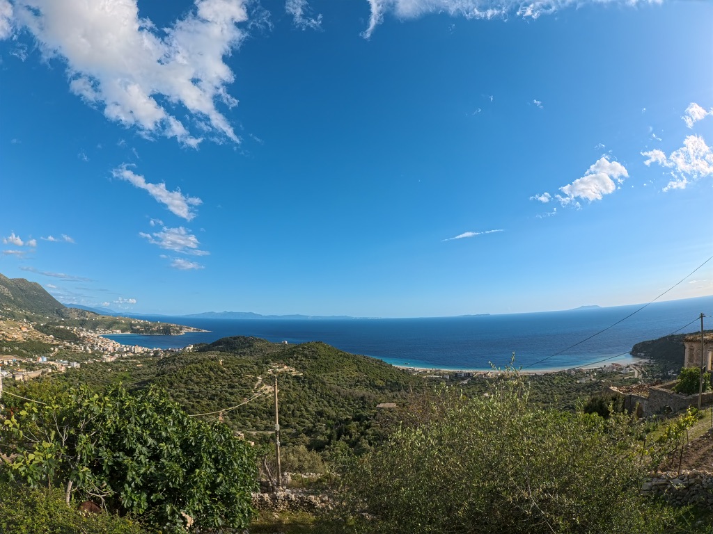
Geography & Why It Looks Like This
Himara sits on the narrow coastal strip between the Ceraunian Mountains and the Ionian Sea. The mountains rise sharply — Mount Çikë at 2,044 m is the highest peak of the range and visible from town beaches — creating a geographic isolation that explains much of Himara's character:
- No commercial sprawl from inland: the mountain barrier prevents large-scale agriculture or industry pushing toward the coast
- Distinct microclimate: warmer winters, slightly cooler summers than inland Albania at the same latitude
- Limited road access historically: until the Llogara Tunnel opened on 5 July 2024, traffic from the north climbed over the Llogara Pass at over 1,000 m. The ~5.9 km tunnel cut the Dukat–Palasë drive from roughly 30 minutes to about 7
- Pebble rather than sand beaches: the steep mountain rivers wash limestone and granite pebbles to the coast; sandy deposition is limited
For the heritage and language background that this geography shaped, see About Himara.
Language Demographics
Albanian is the official language. The Greek-speaking community in Himara, Dhërmi, and Palasë is officially recognised as one of Albania's ethnic minorities, but the exact share is contested:
- In the 2011 Albanian census — the last full census to publish ethnicity data — 24.56% of residents in the former Himarë municipality declared Greek ethnicity, 60.38% Albanian. The former Lukovë municipality recorded ~7.3% Greek, and Horë-Vranisht ~83% Albanian. These figures are widely disputed: representatives of the Greek minority report that significant numbers boycotted the ethnicity question, considering the declaration procedure problematic.
- Community estimates and Greek-government-aligned sources give higher figures, often citing 40–50% or more of Himara town residents as ethnic Greek.
- The 2023 Albanian census did not publish ethnicity breakdowns at the municipal level in the same form, so 2011 remains the most-cited official source.
In short: Albanian is the everyday and administrative language; Greek is significantly present in the historic Himarë–Dhërmi–Palasë coastal strip; and the precise percentage depends entirely on the source. Signs on many heritage sites carry Albanian and Greek, and the local Himariote dialect has features distinct from standard Modern Greek.
For language-specific reference, see the English language and Albania travel guide.
How Himara Compares Demographically (2023 Census)
| Place | Resident population (2023) | Notes |
|---|---|---|
| Bashkia Himarë | 8,328 | Merged municipality — Himarë + Horë-Vranisht + Lukovë units |
| Bashkia Sarandë | 22,613 | Urban centre Sarandë: ~19,882 |
| Bashkia Vlorë | 83,683 | Down from ~175,903 in 2011 (boundary changes + emigration) |
| Vlorë County (qarku) | 146,681 | Whole prefecture, including Himara and Saranda |
Bashkia Himarë is one of the smaller coastal municipalities by year-round population — roughly a third the size of Bashkia Sarandë and a tenth the size of Bashkia Vlorë in the 2023 census. What gives Himara outsized presence on the map is its 571.94 km² area, the string of named villages along the coast, and the very visible summer-season population swing.
Frequently Asked Questions
What is the population of Himara?
The 2011 Albanian census recorded 2,822 permanent residents in the former Himarë municipality (the town and its immediate villages). The 2023 census, after the 2015 administrative reform, recorded 8,328 residents across the entire Bashkia Himarë — which now also includes the Horë-Vranisht and Lukovë units (Dhërmi, Palasë, Vuno, Qeparo, Borsh, and surrounding villages). The Albanian Civil Registry — which counts everyone with legal residence including diaspora — listed roughly 27,049 for the merged municipality in 2015. Summer peaks bring large additional numbers between tourists and diaspora returners, though these are not officially counted.
How long is Himara's coastline?
There is no widely published official kilometre figure for the Bashkia Himarë coastline alone. The municipality stretches from Palasë in the north to Lukovë in the south, and is part of the Albanian Riviera, which is generally cited at 100–150 km from Vlorë to Sarandë. The Ceraunian Mountains running parallel to it are about 100 km long. Within Bashkia Himarë are roughly a dozen named beaches and several major coves.
What's the climate of the Himara coast?
Mediterranean (Köppen Csa) — hot dry summers and mild wet winters. Average July highs around 30 °C, January highs around 12 °C, sea temperatures peaking near 25 °C in August and bottoming near 14 °C in February. Annual rainfall is reported between roughly 1,270 mm (WeatherSpark) and 1,598 mm (Climate-Data.org), concentrated in October to December. See best time to visit Himara for detailed month-by-month.
What languages are spoken in Himara?
Albanian (official) and Greek (a recognised minority language with a long Himariote dialect history). In the 2011 census, 24.56% of residents in the former Himarë municipality declared Greek ethnicity, though community estimates run higher and the census ethnicity question was partly boycotted by minority representatives. Many heritage sites have signage in both Albanian and Greek. English is widely understood in tourist contexts.
Why is Himara's coastline so different from sandier beaches in Albania?
The Ceraunian Mountains rise sharply directly inland from the coast, feeding steep rivers that wash limestone and granite pebbles to the shore rather than building up sand. The result: dramatic pebble-and-cove coastline with exceptional water clarity (less sediment), versus the sandy plains north of Vlora or the engineered sand beaches of Ksamil.
For the broader entity story — history, heritage, dialect, geography in depth — see About Himara. For travel planning, the Albanian Riviera travel guide.


