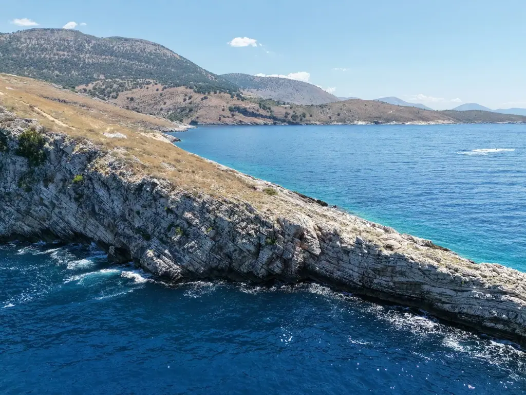
Aerial view of Cape of Rigon, a tilted layered limestone headland with dry grass on top, running into deep blue sea south of Himara
landmark

Cape of Rigon

Kierunek z Himary
Na południe
Odległość drogą morską
South of Himara by sea, about 700 m past Filikuri Beach
Postój na kąpiel
Usually seen in passing; not a fixed swim stop
Dostęp
Best seen from the sea; open water with no beach at the tip

Cape of Rigon is the layered limestone headland between Filikuri and Llamani, south of Himara. Seen from the boat on southbound coastline tours.

What Cape of Rigon Is

Cape of Rigon is a headland on the coast south of Himara, between Filikuri Beach and Llamani Beach. It is not a beach and there is nothing to land on at the tip. The rock layers are tilted steeply and slope down into the sea, with dry grass and scrub on top. The water off the point is deep, dark blue.

Seeing It from the Boat

The cape is what you round after leaving Filikuri, before the coast turns east toward Llamani. It is not a fixed swim stop. Southbound boats pass close enough to see the layered rock and the sea breaking along its base.

  • The best photos are side-on from the water, where you can see how the layers tilt
  • The point faces open sea, so it catches more swell than the coves on either side
  • Swimming happens at Filikuri and Llamani, not off the point

Bunkers

Photos posted by contributors on Google Maps show a concrete-lined bunker entrance built into the rock face. OpenStreetMap marks four bunker entrances in a line about 250 m east of the point, on the Llamani side. No source we found gives a date or purpose for them, so this page does not guess.

Getting There

Most visitors see the cape from a southbound coastline tour or a Porto Palermo trip from Himara, both of which pass it. We could not confirm a trail to the tip. For walking access on this stretch, see the Filikuri trail guide, which goes as far as the beach.

Want to see the coast south of Himara? Browse Porto Palermo boat tours from Himara on GetYourGuide for fixed prices, free cancellation and verified reviews.

Woda

Deep, dark blue water off the point, turquoise over the rock shelves in the lee

Najlepszy czas

Calm mornings, when the swell is down off the exposed point

Idealne dla

PhotographyCoastline scenery

Położenie na Riwierze

Zwykle w programie

  • Southern coastline tours from Himara
  • Porto Palermo routes (passed on the way)

Cape of Rigon na zdjęciach

Rejsy z przystankiem w Cape of Rigon

Żadna stała trasa nie ma Cape of Rigon w planie przystanków.

Przewoźnicy z Himara mogą dodać to miejsce do prywatnego czarteru. Możesz też przejrzeć wszystkie rejsy z miasta.

Przeglądaj rejsy z Himara

Inne rejsy z Himarë

Porto Palermo – pół dnia

ok. 3–4 godzinyod ok. 20 € za osobę
Sprawdź terminy i ceny

Jaskinia Piratów – pół dnia

ok. 3 godzinyod ok. 30 € za osobę

Organizator: Himara Sea Escapes

Sprawdź terminy i ceny

Zatoka Grama – cały dzień

ok. 5–5,5 godzinyod ok. 58 € za osobę

Organizator: Aqua & Terra Drymades

Sprawdź terminy i ceny

Wydłużone długie rejsy

ok. 6+ godzinod ok. 80 € za osobę
Sprawdź terminy i ceny

Najczęściej zadawane pytania

Where is Cape of Rigon?+

It is the headland on the coast south of Himara, about 700 m south of Filikuri Beach and 1.5 km west of Llamani Beach. Boats heading south from Himara toward Porto Palermo pass it between those two stops.

Is Cape of Rigon a swim stop on boat tours?+

Not usually. Himara operators list Filikuri and Llamani as the swim stops on this stretch, and none we checked names the cape as a stop. You see it from the boat on the way. If you want to stop or swim near the point, ask the skipper before you book.

Is there a beach at Cape of Rigon?+

No. The tip is a rock point with cliffs dropping straight into deep water. The nearest beaches are Filikuri to the north and Llamani to the east.

Are there bunkers at Cape of Rigon?+

Contributor photos on the Google Maps listing show a concrete bunker entrance cut into the rock, and OpenStreetMap marks four bunker entrances about 250 m east of the point. We could not find a source for when they were built or what they were for.